
“I have recently commissioned Monument Geomatics to provide a Topographical survey of a large piece of farmland in St. Briavels in the Forest of Dean. In addition to the survey Monument has also provided several 3D visualisations and volumetric calculations.
I was impressed with the quality of the information provided and the speed of delivery from the initial site visit to the production of clear and professional looking plans. Due to the complexity of the required deliverables, I have found the flexibility and the willingness of Monument staff to accommodate my requirements essential in order to meet time and technical restrictions.
I will turn to Monument for all Land Survey work required for future projects.”
Jason Babbage, Director, J&S Babbage Ltd Building Contractors
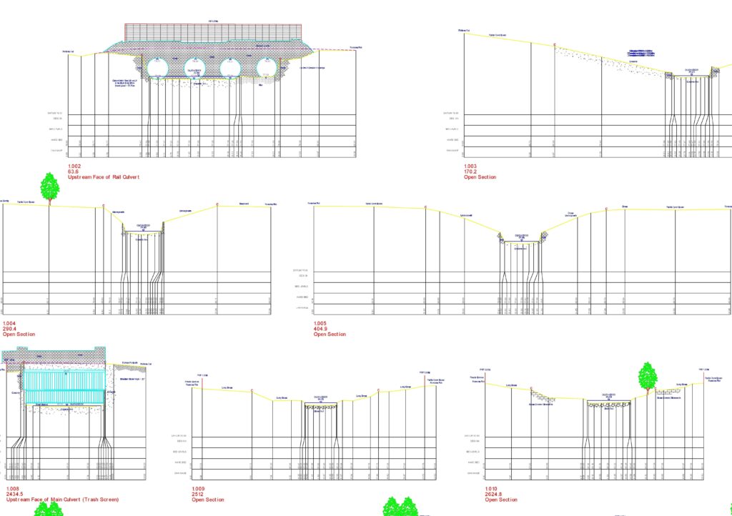
“Monument Geomatics undertook a channel and structure survey for a number of sections of watercourses in Coventry as part of a wider flood mapping project Halcrow is undertaking for the Environment Agency. The survey provided was of a very high quality, produced in the required timeframe and to a very competitive price. Monument Were accommodating in carrying out additional requirements at short notice, and overall a real pleasure to deal with. We will be looking to use Monument again in the future.”
Becky Dunn, Project Manager, Halcrow Group Ltd.
“Monument Geomatics have provided me with five topographical surveys for use on our term contracts with Worcestershire County Council and North Somerset Council for highway improvement proposals in the short time their company has been established.
They work to our in house specification so their deliverables import seamlessly into our design systems (Autocad and MX) with layering and string conventions fully adhered to.
Monument have mobilised at short notice when required and all surveys have been delivered ahead of programme.
In all, I am very satisfied with the services they have given, it has been equal, if not better than when we had a large in-house Geomatics team at our disposal.”
Jamie Wyllie, Project Manager, Halcrow Group Ltd.
“Monument Geomatics have undertaken a number of topographic and tree surveys on Phase 1a of the Cotswold Canal Restoration on behalf of Halcrow and Stroud District Council. The Cotswold Canal Restoration Phase 1a is a project to restore to navigation a 6 mile stretch of the Stroudwater and Thames and Severn Canals, collectively known as the Cotswold Canals, through Stroud and is a £25M project. The topographical surveys undertaken by Monument include structures, channel works and areas such as industrial estates. Monument have offered a very cost effective service with all surveys carried out within the agreed timescales, to the budget agreed and to the desired level of quality. They have been easy to deal with and flexible to last minute changes and requests to pick up additional information or areas while still on site. I would have no hesitation in recommending them.”
Paul Williams, Project Manager, Halcrow Group Ltd.
“We are small design and planning consultancy based in the Forest of Dean, dealing predominantly with residential schemes of varying scale. For the majority of planning applications submitted in the past 12 months Monument Geomatics have provided supporting information in the form of Topographical Surveys, Landscape and Flood Risk Assessments.
The largest scheme in which we have worked together has been a regeneration scheme in Newent with an anticipated construction value approaching £1.5m. Due to its location within a conservation area and flood zone 3, substantial supporting information was required to aid both the building and drainage design. Monument provided a topographical survey for the majority of Newent town centre to aid with drainage design for overland flood routes whilst also producing the supporting Flood Risk Assessment to satisfy EA requirements. Both were produced very quickly and with an exceptional level of detail to allow the application to progress without delay.
Monument Geomatics have continually provided us with a very professional and efficient service and we hope our strong working relationship continues into the future.”
Ian Drew, Director, I-Design Consultancy
“Monument Geomatics have provided us with topographical surveys on a variety of projects, including Cheltenham FAS and Glynbridge Gardens. Without exception the service they have provided has been swift and extremely thorough. We will have no hesitation in using them on our forthcoming projects.”
David Pearce, Project Manager, Halcrow Group Ltd

“We commissioned Monument Geomatics to produce a topographical survey for phase 1 of our Ermin Street road safety and traffic management scheme in Brockworth Gloucester. Ermin Street is a developer funded scheme with an approximate overall budget of £800,000, of which phase 1 costs £250,000.
The topographical survey was produced on time, to budget and in the format we requested. The prompt and efficient service we received from Monument has led us to award them the site work setting out contract as well.”
Haydn Collier, Principal Engineer, Gloucestershire Highways“Opens up fine in MX and a pleasure to have the strings labelled correctly! Many thanks for getting this done so quickly.”
David Boyd, Design Engineer, Gloucestershire Highways“Thank you for turning this job around so quickly. I will certainly recommend you for future projects.”
Michael Drake, Michael Drake Architects“We are delighted with the survey, Many Thanks”
Mrs Nunn, Land Owner